- Create Your Own Playlist! Ask Us How!
Create Your Own Playlist! Ask Us How!
Create your own custom playlist! Let us host the content for hassle free anytime anywhere delivery. Contact us to find out how easy it can be!
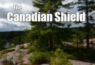
Our Canada - The Canadian Shield
Width Height
Grade Level: 3 - 5, 6 - 8, 9 - 12
The largest of Canada's geographic regions, the Shield is a massive horseshoe shaped area covering almost half of Canada. Made famous by the paintings of the Group of Seven, it is a landscape shaped by glaciers during the Ice Age. The rounded hills of igneous and metamorphic rock have been eroded and smoothed over time. Within these rocks lie minerals such as gold and silver. The Shield has been home to Aboriginal people for thousands of years. Today, they fight to maintain their culture as mining and hydroelectric stations threaten their traditional way of life.
Includes PDF Resource Guide.
|
Running Time: 14:56 Country of Origin: Canada Captions: |
Producer: McIntyre Media Inc. Copyright Date: 2016 Language: English |
Video Chapters
-
The Canadian Shield 1:21
The largest of Canada's geographic regions, the Shield is a... -
The Formation of the Canadian Shield 2:14
The Canadian Shield is the largest mass of pre-cambrian rock on... -
The Landscape of the Canadian Shield 1:35
The Canadian Shield is covered by large Boreal forests. Boreal... -
Indigenous Peoples in the Canadian Shield 1:24
The Canadian Shield has been home to Aboriginal people for... -
Minerals Found in the Canadian Shield 1:51
The soil in the Canadian Shield is very shallow, making it... -
Natural Resources in the Canadian Shield 1:52
The large forest population has created a large pulp, paper and... -
Recreation and Tourism in the Canadian Shield 00:48
The Canadian Shield region is an amazing place for people from... -
Climate in the Canadian Shield 2:20
The north part of the Canadian Shield borders the Arctic Ocean...
TRANSCRIPT
Close- The Canadian Shield is the largest of Canada's six physical regions. It is a massive horseshoe-shaped area that covers almost half of Canada. If you drive along the Trans Canada Highway from Ottawa through Sudbury to Canora, you're driving through Canadian Shield country. The landscape you see is mostly rocks and trees and trees and rocks, with lots of lakes, swamps, and rivers. That's what you see almost everywhere in the Canadian Shield.
- A group of seven Canadian artists such as Tom Thompson created paintings of the Shield area that became world-famous. Long before writing was invented, First Nations people recorded events and ideas by painting on the Shield rock faces. Pictographs-- prehistoric paintings on rock. These pictographs can be easily accessed at places like the Agawa Rock in Lake Superior Provincial Park and the cliff at Bon Echo Provincial Park. Some First Nations people also carved images into the rock, and these petroglyphs are carefully protected at places like Petroglyphs Provincial Park near Peterborough, Ontario.
- Petroglyphs are prehistoric carvings on rock. The Canadian Shield is the largest mass of precambrian rock on Earth. This ancient rock was formed during the precambrian period in Earth's history over millions of years. In fact, this rock was formed by volcanoes. It's hard to believe that this part of Canada once had a lot of volcanic activity.
- When you look at rock in this area, think about the fact that it is at least 540 million years old, and maybe even billions of years old. It is hard to comprehend that length of time. But some of this rock probably existed before there were any living things on Earth. That's a long time ago.
- The Canadian Shield includes some of the Arctic islands, the Northwest Territories, and Nunavut around Hudson's Bay, through Manitoba, across northern Ontario and Quebec, and northeast through Labrador to Greenland. The landscape we see today in the Shield area was shaped by glaciers during the ice ages. Massive sheets of thick ice push loose rock ahead like a giant bulldozer and carry it further south. It was left as soil and gravel when the glaciers retreated or began to melt. Over several glacial periods, the moving ice gouged out basins where the lakes and swamps are found today, and much of the rock was smoothed by the moving ice.
- Did you know Ontario has over 250,000 lakes containing almost one-fifth of the world's fresh water? Over a long period of time, erosion wore down the rock in the Canadian Shield.
- The rounded hills in the Shield have two types of rock. Igneous rock, which is also called fire rock, was formed when molten rock cooled and became solid. This produced rocks like granite or quartz. Minerals such as gold and nickel are found in igneous rock. Metamorphic rock formed when heat or pressure acted on igneous or sedimentary rocks, producing rock such as slate or marble.
- All of this water and rock can make transportation difficult. In the northern areas of the Shield, there are few roads, so people often travel by snowmobile, ATV, plane, or boat. Groceries and supplies are very expensive for people living in the remote parts of the Shield because delivery is costly. In winter, trucks can sometimes use winter roads which pass over frozen lakes and rivers. But as climate change brings rising temperatures, this is becoming more difficult.
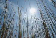
- The Shield is covered by large boreal forests. Boreal means "of the north." 75% of Canada's forests are in the boreal zone. Coniferous forests with spruce, fir, and pine trees are green through the winter. Deciduous trees like larch and poplar drop their leaves in the fall. Further north, the Arctic tundra is covered with shorter trees and low-growing plants that can survive in shallow soil with a short growing season.
- Tundra is a treeless plain in subarctic and arctic regions. A lot this area is covered in permafrost, where the subsurface of the soil remains frozen year-round. What do you think will happen to roads, buildings, and pipelines that are built on permafrost if climate change continues to cause rising temperatures?
- People have noticed that the upper layer of permafrost in the north is thawing. When permafrost melts, the land above it becomes less stable. Sinking land can damage buildings, roads, and airports, as well as water and sewer pipes that are built on it. Ecosystems are also affected. Trees begin to tilt or fall over as the ground thaws, and the carbon trapped in it is released as methane gas. This greenhouse gas contributes to more global warming.
- The Shield has been home to aboriginal people for thousands of years. Cree First Nations occupy subarctic territory from Alberta to Quebec. The James Bay Cree families still have hunting camps in the bush where they go to hunt, fish, and trap. Elders are responsible to remember and teach the traditional ways and beliefs.
- Algonquin people, including the Ojibway, lived further south in the Shield region. They also hunted, fished, and trapped on the land. The women processed animal hides to make clothing and moccasins. Canoes carried them along lakes and rivers, and transportation in the winter was by toboggan, snowshoe, and sled. Wild berries were often mixed with pounded dry meat and fat to make pemmican, a high-energy food that was easy to take on voyages into the wilderness.
- In the St. Maurice area of Quebec, Atikamekw families also lived off the land, and today they are fighting to preserve their traditional culture. The Inuit people hunted in the eastern boreal forests of the Labrador peninsula, following the animals with the seasons. Every part of the caribou was used for food or to make clothing, drums, and other necessities.
- The soil in the Shield area is very shallow, and when Europeans began to arrive here to farm, they were disappointed by the poor crops. Insects like black flies and mosquitoes also discouraged the settlers, and many of them moved further south to the Great Lakes and St. Lawrence lowlands, where the soil was deeper and richer.
- When the Canadian Pacific Railway was being built through the Shield, workers blasted through the rock. To their surprise, they found minerals such as gold, silver, and copper in the rock. Towns developed where people worked in the mines. One of the largest mining towns is Sudbury, Ontario. Large deposits of nickel were found here in 1883.
- Did you know the Sudbury basin is one of the most unusual geological formations in Canada? It was probably formed when a meteorite or comet landed here approximately 1.8 billion years ago. The resulting large crater filled with molten rock from deep in the Earth, and this magma produced many valuable minerals.
- While Canada is a major producer of important minerals and metals, there are concerns about some of the mining processes. Mineral extraction can destroy vegetation and forest wildlife to move to new habitats. In some areas, mines also impact nearby aboriginal communities. Pollutants can contaminate their water and food sources. Greater Sudbury in Ontario has made a significant effort to restore the landscape through a tree-planting program. And many companies are now working to reduce the environmental impact of their mining operations.
- Many other natural resources in the Canadian Shield region have provided materials for industries and jobs. The forests here led to the development of a large pulp and paper industry. About half of Canada's annual wood harvest comes from this region. Ontario and Quebec companies provide wood for furniture makers, for flooring, and for building construction. They make wood pellets for heating, cardboard for packaging, and paper for offices, newspapers, and book publishers.
- The water flowing in the Shield's rivers lead to the development of hydroelectric power plants that generate electricity. The province of Quebec is Canada's largest producer of hydroelectricity. The power of moving water turns turbines, which are connected to a generator that produces electricity.
- Often dams are built to create a water reservoir. The stored water can then be channeled to flow through a power-generating station. Hydroelectric power is an important source of renewable energy in Canada, but when a dam is built, the flooded area can have negative effects on the natural environment and the residents. Traditional aboriginal ways of life can also be threatened. When the huge James Bay hydroelectric project was built in the early 1970s, it flooded 11,500 square kilometers of land that was home to the James Bay Cree and Inuit people. In 2002, the Cree nation and the Quebec government signed an agreement to share revenues from future hydroelectric developments.
- The natural beauty of the Canadian Shield leads to employment in recreation and tourism business. Cottagers, campers, and hikers have been enjoying summer vacations in the Muskoka area of Ontario for years. Residents in Thunder Bay love to go to their camps in the woods north of them. The Laurentides area in Quebec attracts tourists in the summer, and also is great terrain for winter skiers and snowmobilers. If you like to fish, camp, hike, swim, water ski, snowmobile, canoe, ride horseback, or cycle, the many national and provincial parks in the Canadian Shield are there for you.
- Because the Canadian Shield is so large, the climate is very different across the region. In the north, the Shield borders the Arctic Ocean, where dry, frigid winds create very cold temperatures during the long winter months. The northern summers are short and cool with very long days. On June 20th in Iqaluit, Nunavut, the sun rises soon after 2:00 a.m. And does not set until 11:00 p.m. That's a long day. The growing season is short, but the amount of daylight in summer makes plants grow quickly.
- Further south in Shield, you'll also find cold winters with some heavy snowfalls. Summers are warmer, and the growing season is longer. This area can have many forest fires. But this is nature's way of releasing nutrients into the soil and pruning the forest so that new growth can begin.
- The Shield is home to many different types of wildlife. Carnivores such as bears, wolves, lynx, and foxes feed on smaller animals. Carnivores are flesh-eating mammals. Herbivores, such as caribou, deer, moose, raccoons, chipmunks, and rabbits, live on the plants and nuts growing in the forest. Herbivores are plant-eating mammals. Birds of prey like owls, vultures, and eagles feed on small mammals. And people travel from many places to fish in the lakes of the Canadian Shield.
- There are some wonderful cities found in the Canadian Shield as well. Ottawa, Canada's capital, is on the Ottawa River. Churchill, Manitoba, the polar bear capital of Canada, is on the shore of Hudson's Bay. Iqaluit, Nunavut, the home of many Inuit people, is on Baffin Island at the north end of Frobisher Bay, and the town of Happy Valley Goose Bay in Labrador was once an important refueling stop for airplanes flying across the Atlantic Ocean when they had smaller fuel tanks.
- We hope you've enjoyed this video tour of the Canadian Shield. This beautiful area of Canada needs to be preserved for the future. It has a wealth of varied landscapes, recreational opportunities, resources, and employment. If you don't already live here, perhaps one day you will travel to or even move to this largest geographical region of Canada.
TRANSCRIPTS:
Interactive Transcript
Transcript (PDF)